
Lake Victoria Water Pollution Part 1 – Introduction
Training Resource Description
Lake Victoria is Africa’s largest freshwater lake and the world’s second largest by surface area. It is a vital resource for over 47 million people across five countries – Burundi, Kenya, Rwanda, Tanzania, and Uganda – supporting diverse ecosystems and providing essential resources and livelihoods for surrounding communities. However, it is increasingly under threat from climate change, pollution, overexploitation, invasive species, habitat destruction, and eutrophication. As a result, the quality of the lake’s water is deteriorating, with devastating effects on local livelihoods, including reduced fish stocks, diminished biodiversity, and worsening public health.
In response, the World Bank is working with the Lake Victoria Basin Commission, who are mandated to coordinate sustainable development and management of the Lake Victoria Basin across the five East African Community (EAC) Partner States, to develop the Lake-wide Inclusive Sanitation (LWIS) Investment Strategy to address these challenges. The GDA Water Resources activity is supporting this effort by providing Earth Observation (EO) based services for water quality monitoring, assessing dynamic changes, and analysing the main drivers of pollution. EO technology enables monitoring of key water quality parameters, such as turbidity, chlorophyll-a, and harmful algae blooms, helping to understand the drivers of water quality changes and to evaluate the impacts of water management infrastructure projects.
In this video, you will hear from representatives from the Lake Victoria Basin Commission and the World Bank, who share insights on the lake’s challenges and efforts to safeguard its resources.
Related resources and websites
- GDA Story: Battling Pollution in Lake Victoria – Read more about the Lake Victoria project on the GDA website.
- Collaborative efforts to improve sanitation and water quality – World Bank video on Lake Victoria’s challenges and the collaborative efforts to address them.
- Reviving Lake Victoria: A Regional Approach to Inclusive Sanitation – This World Bank report outlines a regional strategy to improve sanitation and water quality in the Lake Victoria Basin.
Featured Imagery
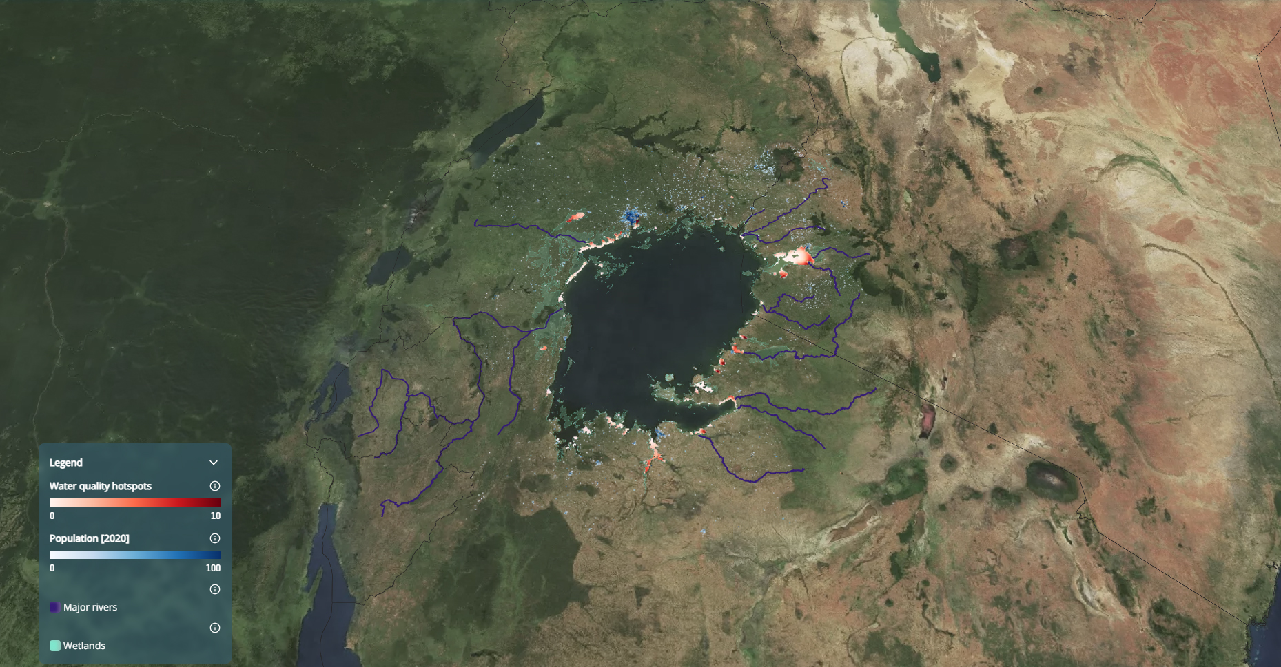
This image highlights water quality hotspots around Lake Victoria. The red shaded areas indicate locations with higher concentrations of water quality issues, often linked to pollution, urban runoff, and agricultural activity. The blue shaded areas show a high population density illustrating how many hotspots occur near densely populated shoreline areas. The dark blue lines show the major rivers flowing into the lake, which can carry nutrients and contaminants from surrounding regions..
Source: GDA Water Resources / GDA Impact Sphere
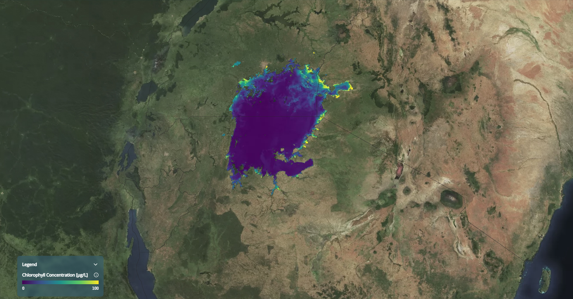
This image shows Chlorophyll Concentration around Lake Victoria. Colours range from purple (low concentration) to green and yellow (higher concentration). Higher chlorophyll levels are mainly visible along the shorelines and shallow bays, where nutrient inputs from rivers, wetlands, and nearby human activities can stimulate algal growth.
Source: GDA Water Resources / GDA Impact Sphere