Using Satellite Imagery to Support Property Valuation and Urban Revenue Generation in Rwanda
Satellite imagery from the EO4SD-Urban project was used to improve property valuation and tax mapping in Kigali, Rwanda, helping enhance local revenue collection and support urban development planning.
Description
In Phase 1 of its implementation (2016–2017), the ESA EO for Sustainable Development (EO4SD) Urban initiative collaborated on a World Bank (WB) project focused on a pressing issue in many developing countries: the difficulty of accurately valuing land and property due to outdated or incomplete data. This challenge significantly impacts the ability of local governments to generate revenue through property taxation.
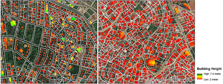
To address this issue, EO4SD-Urban provided high-resolution building footprint and height data derived from Pleiades satellite stereo imagery. These Earth Observation (EO) products were used alongside land price data to support property valuation modeling in Kigali, Rwanda. By combining EO-derived urban structure data with economic indicators, the project offered a more objective and scalable approach to estimating taxable property values.
The results of this collaboration were highlighted in the World Bank Policy Research Working Paper “Using Satellite Imagery to Revolutionize Creation of Tax Maps and Local Revenue Collection“ by Daniel Ali, Klaus Deininger, and Michael Wild. The study acknowledged the support of ESA and the EO4SD-Urban project, emphasising the significant potential of EO-based tools to enhance property tax systems and support urban policy in African cities.
This case demonstrates how satellite-based geospatial information can play a transformative role in modernising land valuation practices, thereby helping governments in low- and middle-income countries strengthen local revenue generation and urban planning capabilities.