
EO Supporting the Assessment of Urban Master Plans in Tanzania
The EO4SD-Urban project supported the World Bank in assessing urban planning effectiveness across seven major Tanzanian cities by using satellite data to compare actual land use with existing master plans.
Description
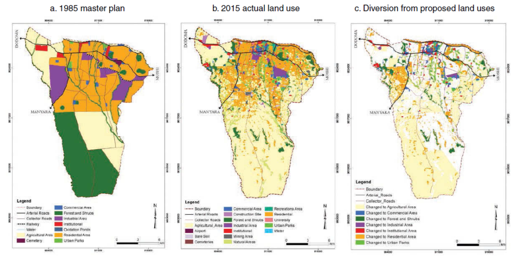
The EO4SD-Urban project supported the World Bank technical assistance project Urban Planning Study – Impact & Effectiveness of Urban Planning on City Spatial Development in Tanzania. Focusing on seven of the country’s fastest-growing and most populous cities—Tanga, Arusha, Mwanza, Kigoma, Dodoma, Mbeya, and Mtwara—the project delivered satellite-based mapping and spatial analytics to assess urban development trends and planning outcomes.
The EO4SD-Urban consortium, led by GAF AG with partners NEO, GISAT, and DLR, generated data products covering urban and peri-urban land use and land cover, informal settlements, urban green space, transport networks, and population distribution. These data were instrumental in evaluating the extent to which current urban development aligns with existing master and detailed urban plans.
A key finding was that only 35–45% of land use in the studied cities conformed to the original urban plans, revealing significant discrepancies—especially in peri-urban areas. The insights provided by EO products helped the World Bank and local stakeholders identify gaps in planning effectiveness, improve understanding of urban growth patterns, and support evidence-based policymaking for more sustainable and inclusive urban development strategies.
You can read more about this Case Study here: [EO4SD] Earth Observation Supporting the Assessment of Urban Master Plans in Tanzania